We have reached the final week (for now…) of Sussex Unwrapped! It is the turn of Chichester this week, and we thought it would be a great idea to run through the centuries to sum up the history of Chichester as a a market town and cathedral city. Let’s see what has changed shall we?
Chichester on Film

Snippet from the film Chichester: A Georgian City on Vimeo by Screen Archive South East, part of the series for West Sussex Unwrapped.
Images should not be reproduced without permission from West Sussex Record Office.
Chichester in the Archives
Chichester has the distinction of being the only city in West Sussex as well as being the County Town. The founding of Chichester is usually attributed to Noviomagus Reginorum. This roughly translates to the ‘new plain of the Regini’ (the name given by the Romans to the locals). The Roman city was connected to London through Stane Street – which ran from Eastgate up to London Bridge – and was built in the typical Roman style with a north, south, east and west street. There are significant chunks of Roman Chichester that have survived, not just Fishbourne Palace down the road, but you can head over to the Novium’s website to read more about Roman Chichester!
Medieval and Tudor Chichester
With the beginning of Anglo-Saxon Britain, Chichester became the chief city in the Kingdom of Sussex, and after the Norman conquest we know – thanks to the Domesday Book – that Chichester consisted of 300 dwellings which held a population of 1,500 people. The bishopric moving here from Selsey in 1075 would have perhaps helped Chichester’s population growth to a decent size by the time the Domesday Book was compiled.
When looking at the growth of medieval Chichester, ChiCity – the Chichester City Archives – holds some of our oldest records for the entire County. Below we have a royal charter of Henry II’s in around 1155.

Written in Latin, a rough translation reads as follows:
“Henry, King of the English and Duke of the Normans and Aquitanians and Count of the Angevins, to his Justiciars and Sheriffs and servants throughout England, greeting. Know that I have granted to my citizens of Chichester who are of the Gild Merchant all their liberties and free customs within and without the borough that they may have them everywhere as fully and freely and quietly and honourably as they were wont to have them in the time of King Henry my grandfather. And let no one sell cloth in the city of Chichester by retail unless he is of the Gild Merchant as the same King Henry ordered by his writ. Wherefore I will and firmly enjoin that they may have and hold their gild with all the liberties and customs thereto belonging in the best manner as they were wont to have them in the time of King Henry. Let no man presume to wrong them in this matter. Witness, Reynold, Earl of Cornwall, Henry de Essex the Constable, Ranulph de Broc, at Bridgenorth.”
A royal charter is a formal grant issued by a monarch that, in medieval times, was often used to give rights and privileges to towns, boroughs and cities. In the above instance, it was Henry II ensuring certain liberties involving trading and selling with city guilds and their members.

Another Royal Charter, made many centuries later by Henry VIII in 1526, is notable for its intricate artwork detailing Henry sat in his royal regalia, alongside the Tudor rose and Catherine of Aragon’s pomegranate and rose emblem. Also written in Latin, ChiCity A/8(15) has sadly not been translated as some of the earlier charters have. However, it is significantly larger than Henry I’s charter, and runs over two pages.
Alongside its city status, Chichester also was the centre of the Diocese. The Cathedral was consecrated in 1175, though it continued to be added to throughout the centuries, including the ill-fated spire which would later collapse in 1861 (which you can more about on another blog post here). The images below, painted by Peter Iden, show an impression of what medieval Chichester and its Cathedral could have looked like for the first 350 years.

PD 2974 – Watercolour of impression of how Chichester Cathedral would have looked in 1150-1200, painted by Peter Iden, c1986 
PD 2975 – Watercolour of impression of how Chichester Cathedral would have looked in 1500, painted by Peter Iden, c1986
Stuart and Georgian Chichester

Speaking of the Cathedral, our Capitular records also provide a look at central Chichester throughout the centuries. Our oldest records come from this collection (see our blog on the Oslac Charter) and carry through to the 20th century. Here we have a page from Cap VI/1/1, a manuscript music book dating from the 17th century. John Walter was the organist at Eton College between 1681 and 1704, and this volume contains his handwritten copies of music by John Blow and Henry Purcell. You can read more about this piece on a blog written by Anthony Cane, former Chancellor of Chichester Cathedral, by clicking the link here.
Another great way to show the changing landscape of an area is maps. As maps have become less abstract and more about showing – to scale – details of buildings and roads, so too has Chichester’s position in West Sussex and the South of England changed in its prominence.
This late Elizabethan/early Stuart map by Nordon shows the entirety of West and East Sussex, but has a detailed insert of the Cathedral city. From this insert you can clearly see the walls that surround the city (and Priory Park) as well as the route the river Lavant took around the city walls.

PM 24 – Copy of Norden’s map of Sussex, originally published 1595 
PM 24 – Close up of insert of Chichester within Norden’s map of Sussex, originally published 1595
ChiCity AZ/2 aka ‘The Brown Book’ is a compilation of copies of different charters, statutes, leases and so on to provide a sort of overview of the rights and privileges of the Chichester Harbour and canal. We think it dates from the late 17th century. Included inside the front cover is this delightful map of Chichester and the surrounding coastline. The point of the map is to show the extent of the port of Chichester, so the city itself is relegated to being a circle. It only shows the four main streets leading over to Portsmouth/Southampton and south to Dell Quay (note the different spelling)!


We can jump forward several decades to take a more detailed look of Chichester’s growth in PM 154, dated 1812 and made by G Loader. Important landmarks of Chichester are labelled in the key at the bottom, including the Cross; St Peter the Less, All Saint’s, St Andrew, St Martin, St Olave and St Pancras churches; St Mary’s Hospital, and – of course – the Cathedral.
Sadly, the Tithe Map of central Chichester has not braved the years well, but with the city being the centre of the Diocese, its growth and changes are well illustrated over the centuries, until OS maps allow the most in depth looks at the geography of the town.
As for what Chichester actually looked like, an (idealised) painting by Joseph Francis Gilbert and later engraving by M Dubourg shows the East Street Market in 1814. The number of characters present in this painting could probably have an entire blog post dedicated to themselves, but it’s fascinating to see the interesting perspective used to show the breadth of East Street and the people going about their daily lives.


Victorian Chichester
Victorian Chichester saw a growth both in its population and economy, leading to the construction of some of the more interesting buildings in the city centre. For example, here we have PD 2807, which shows the Corn Exchange, in 1833. Built over a year between 1832 and 1833, the Chichester Corn Exchange was one of the first to be built in Britain.

Before its construction, trading took place near the Butter Market on North Street, but as corn became one of Chichester’s major trading commodities, the Corn Exchange was soon due for a mass expansion of the premises. Designed by George Draper (designer of many of West Sussex’s buildings, including the Chichester Infirmary, St Bartholomew’s Church and the Race Stand at Goodwood), it took only two years for the roof to need replacing, and by 1883 parts of the building were leased of for other uses.
You can read an excellent blog about the Corn Exchange over on the Novium’s website by Pat Saunders if you would like to learn more about the building.

Another major construction was the City Council Chambers, as shown in PD 2591/1 drawn around 1865. The Chambers were built over several decades, with different parts added between 1731 (the Council Chamber) and 1881 (the Mayor’s parlour). Underneath the lion on the Palladian style front facade is text reading:
IN ORDER THAT THE COUNCIL AND THE PEOPLE OF CHICHESTER
AND THEIR POSTERITY MIGHT BE HAPPY AND FORTUNATE,
THIS COUNCIL HOUSE WAS BEGUN AND COMPLETED IN THE
YEAR OF OUR LORD 1731,
IN THE REIGN OF GEORGE II, ELECTOR AND KING
Moving back to churches, there was a growth in Anglican and Non-Conformist churches being built during the 19th century. Two of the images below show part of Par 39/64: ‘Plans, Elevations and Sections with a Description of the new chapel of St. John in the city of Chichester by James Elmes, Architect’. Built on an octagonal base, the idea was to have a larger central pulpit – ideal for Evangelical style preaching. At the time it cost £7,000 to build, and was used as a working church until 1973, when it was declared redundant. It was granted Grade I status in 1950. Nowadays it is in the care of by the Churches Conservation Trust, and is a regular venue for concerts.

Prior to the 19th century, there were few schools, and those that did exist tended to be closely associated with the local church, and stressed religious education. Although it was not until the 1880s that children were compelled to attend school, Chichester had a number of schools (for both boys and girls) set up throughout the century. One of these was Chichester’s Lancastrian School.

This school was planned at a meeting in 1810 and opened on Tower Street in 1811 as an all-age school for boys. Despite its title as a Lancastrian school, it was actually not specifically non-conformist. The girl’s school opened one year later in 1812.
On the left we have the first page of E/35/1/1 – Chichester Lancastrian School for Boys minute book, 1811. The inscription on the first page of this book reads: The proceedings of a society for educating the poor of Chichester and its environs on the plan of Joseph Lancaster. On pages seven and nine are the signatures of subscribers and the amounts they gave.
When the school was first opened it consisted of just one large room, but later a smaller room on the south side was added. In 1887, to commemorate Queen Victoria’s Jubilee, the large room was divided by a movable screen, and another class was added at the south-east corner. The infants school is now based just down the road from the Record Office, in Orchard Gardens.
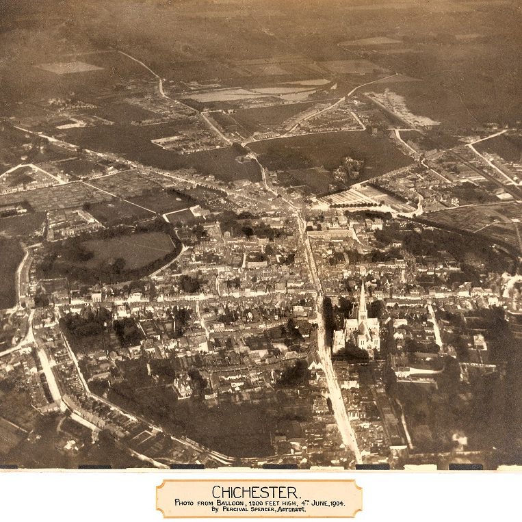
So, what did Chichester look like at the turn of the century? We could look at an OS map, or we could look at the first aerial photo of Chichester. APH 126 shows an aerial photograph of Chichester taken from a balloon by Percival Spencer, aeronaut on the 4th June 1904. It was taken from above West Street and looks towards Portfield and Whyke. It includes nearly all the city centre, but not the railway station (although you can spot the railway line to the east). Included with the photograph is a cutting from the Chichester Observer, 8th June 1904 describing the balloon flight. According to the article, the balloon was flown by Percival Spencer, accompanied by Mrs Manville, Mr F Butler, and Percival’s seven year old son, Charles, and had ascended at Crystal Palace and descended at Nursery Fields. Sounds like quite a trip!


Modern Day Chichester
There had been an army camp near Chichester since the 18th century, but in 1873 it became the garrison for the Royal Sussex Regiment, and eventually gained the name the Roussillon Barracks. As such, the Royal Sussex Regiment has had a formative presence in Chichester.

This poster to the left in particular was printed in Chichester itself, further emphasising the local connections to the regiment. During WWI, Kitchener’s army recruitment resulted in the 7th Battalion being formed (and indeed, many more Battalions to follow). RSR/MSS/7/5 deliberately draws on not only the reader’s loyalty to their country and monarch, but also to the County itself:
We are confident you will help to uphold the honor of the County of Sussex
Check out our assortment of blogs regarding the Royal Sussex Regiment here, here and here! We did a lot of work during the centenary of WWI, so have a browse through our blog to see what else West Sussex did to commemorate the centenary of the First World War.

Moving forward again, Chichester Festival Theatre has, in a manner of speaking, helped put the city on the cultural map. Since its first season in 1962, the Festival Theatre has produced a huge and invaluable archive that was the focus of major partnership project several years ago, funded by the Heritage Lottery Fund. The Festival Theatre used to maintain a shop by the Market Cross in the centre of town, as CFT 7/1/3/2 shows from the 1960s. You can read about the CFT and the amazing records that we hold (some of them quite unexpected) at a previous blog here!

And so, to bring this blog, and Sussex Unwrapped to a close, let’s move even closer to home!
West Sussex Record Office was founded in 1946 and based in County Hall, before moving to Edes House in 1968. In 1989 a new purpose built Record Office was opened to house our ever growing collections. It cost around £2.3 million to build at the time. It was designed to a detailed brief made by the then County Archivist, and it totals 30,000 square feet. This photo shows the exterior during the final stages of building in 1989.
Isn’t it interesting to see how much (or how little) has changed about our home? What are your favourite parts and memories of Chichester? How much has the city changed during your time here?
One more link before you go! If you would like to learn more about the history of Chichester, the Chichester Society in partnership with ourselves and the Heritage Lottery Fund worked on some Heritage Trails. You can read more about the project, and download the routes on the Chichester Society’s website by clicking here.
And that’s all! For now…
Stay up to date with WSRO – follow us on Facebook, Instagram and Twitter
Stay up to date with SASE – follow them on Facebook and Twitter

As a frequent visitor over the last 30 years, I enjoyed learning more about the city and its history. Thank you for this blog and the links. I also enjoy Turner’s views of the Cathedral in his paintings in Petworth House.
Regards, Dr Joseph G Banks, Newcastle upon Tyne
LikeLike
Thank you very much Dr Banks for such a kind comment. I am very glad you enjoyed the blog! Many thanks, Abigail – Searchroom Archivist
LikeLike